
Despite forecasters predicting an above-average hurricane season in the Atlantic for 2022, the activity during August was the lowest for 25 years. But experts from Allianz Global Corporate and Specialty (AGCS) and Allianz Re warn against complacency as we pass the season’s halfway point.
September 10 marked the climatological peak of the Atlantic hurricane season in what was widely expected to be the seventh consecutive year of above-average hurricane activity, with six to 10 hurricanes predicted by the major forecasters.
Instead, the emergence of Hurricane Danielle on September 2 and Hurricane Earl on September 6 ended one of the longest streaks without a hurricane in the North Atlantic in recent history. As of September 10, there have been five named storms in the Atlantic, two of which became hurricanes. For the first time in 25 years, there was a complete absence of named storms in August, in contrast to the 10 that occurred that month in 2021.
The drivers for the high-activity forecasts were the three-year La Niña weather pattern, which minimizes wind shear – an abrupt shift in wind direction or velocity – over the tropical North Atlantic and increases hurricane activity, as well as above average sea surface temperatures (SSTs).
“Both these forecasts were correct,” says Bastian Manz, Senior Climate Risk Analyst at Allianz Re. “However, other, more nuanced and volatile (and therefore more difficult to predict), factors have dominated activity in the North Atlantic so far. High SSTs usually lead to evaporation, and the resulting moisture fuels tropical cyclone development. However, with hot and dry Sahara dust billowing into the main development region, or MDR, over much of the summer, it has simply been too dry.
“The North Atlantic has also seen a high level of wind shear, especially over the Caribbean, which is unusual for a La Niña year, and despite SSTs in the MDR and Caribbean currently being above average, SSTs across the North Atlantic are showing some complex patterns. In particular, extremely warm waters along the coastline from New York to Newfoundland have affected the jet stream, indirectly sustaining the flow of dry air into the MDR.”
"We should not be surprised that activity is finally picking up," says Catastrophe Risk Research Analyst Mabé Villar-Vega, from Allianz Global Corporate & Specialty (AGCS). “Historically, there have been more Category 5 hurricanes in September than any other month. We have seen examples in the past of intense hurricanes occurring after sluggish starts to the season, as well as some particularly intense hurricanes striking after the official peak of 10 September, among them Superstorm Sandy at the end of October 2012 and Hurricane Michael, which made landfall in the Florida Panhandle in mid-October 2018 as a category 5 major hurricane.”
Manz adds that although Superstorm Sandy in 2012 was downgraded to a post-tropical storm just before landfall in New Jersey, its record size contributed to the considerable damage it caused. “Sandy managed to sustain its size and strength due to the high SSTs along the US east coast at the time, not unlike the current situation,” Manz says. “More recently, in 2020, major hurricanes Eta and Iota made landfall in Central America during November, not long before the official end of the season [November 30].”
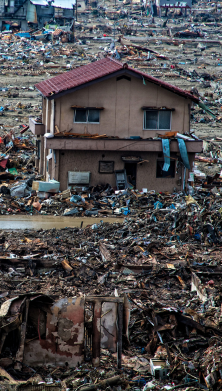
As the North Atlantic hurricane season typically experiences a secondary peak around mid-October, businesses need to remain vigilant about protecting their premises and people, even in a relatively mild hurricane season, the experts advise.
How to prepare for when a storm strikes

Source: NOAA
- A single storm can cause catastrophic damage locally and the National Hurricane Center in the US advises that preparedness plans should not be based on seasonal forecasts. When a hurricane watch is issued for your area, you need to ‘Know Your Zone’ (vulnerable areas will be given an evacuation warning or order) and be aware that authority-ordered evacuation is based on the possibility of storm surge and flooding, rather than pending landfall of a storm.
- Although hurricanes are strongly associated with the US, businesses elsewhere in the world also need to be on their guard against typhoon activity and storm and flood damage.
- To minimize losses in the event of an extreme weather event, businesses should implement a written emergency plan, including actions to take before, during, and after a storm.
- The plan should cover areas such as training, emergency supplies, business continuity, building inspections, anchoring or relocating equipment and stock, protecting windows, flood protection, salvage and recovery, and damage assessment. If you are in the US, visit National Hurricane Preparedness [1] for more information about your risk and how to develop an evacuation plan.
- Allianz Risk Consulting also publishes a series of risk bulletins and checklists to help you protect your people, property, and business, including:
References
[1] National Oceanic and Atmospheric Administration, National Hurricane Preparedness, May 10, 2022
Picture: Adobe Stock
Our experts


All the latest news, reports and hot topics


Newsletter
Keep up to date on all news and insights from Allianz Commercial